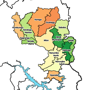
Kpandai District
Kpandai District[1] be one of de sixteen districts wey dey de Northern Region insyd, Ghana.[2] Originally na formerly edey part of de then-bola East Gonja District insyd 1988, til decree of presido John Agyekum Kufuor split de eastern part of de district for 29 February 2008 make dem create Kpandai District.; thus de part wey remain dem retain am as East Gonja Municipal District. De district assembly dey locate for de southern part of Northern Region[3] wey Kpandai be ein capital town.
| Country | Ghana |
|---|---|
| Edey de administrative territorial entity insyd | Northern Region |
| Located in time zone | Greenwich Mean Time |
| Coordinate location | 8°29′0″N 0°1′0″W |
| Dey share bother plus | East Gonja Municipal District, Nanumba South District, Nkwanta North District, Nkwanta South District, Krachi Nchumuru District |

Geography
editDe district dey share boundaries plus East Gonja for de west, Nanumba South for de north, Nkwanta North den Nkwanta South for de East den Krachi West for de south.
Population
editDe district be largely rural, plus approximately 90% of de population dey engage for local agriculture insyd.[4] As of de 2010 census, na de district population be 108,816 wey dey include at least 24 different ethnic groups.[4] De district get total population of 108,816, wey dey make up of 54,997 (50.54 percent) males den 53,819 (49.46 percent) females. De district get urban population of 10,824 wey dey represent 9.9 percent den rural population 97,992 wey dey represent 90.1 percent.
References
edit- ↑ "One District One Factory (1D1F)". www.moti.gov.gh. Archived from the original on 2021-04-11. Retrieved 2021-04-11.
- ↑ "Northern » Kpandai". Archived from the original on 2013-03-05. Retrieved 2013-06-18.
- ↑ "Ghana Northern Region". www.modernghana.com. Retrieved 2021-04-11.
- ↑ 4.0 4.1 Ghana Statistical Service (2014). "2010 Population & Housing Census: Kpandai District Analytical Report" (PDF). Archived from the original (PDF) on 2016-03-05. Retrieved 2018-10-13.
